
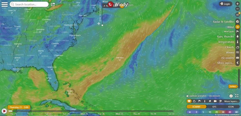
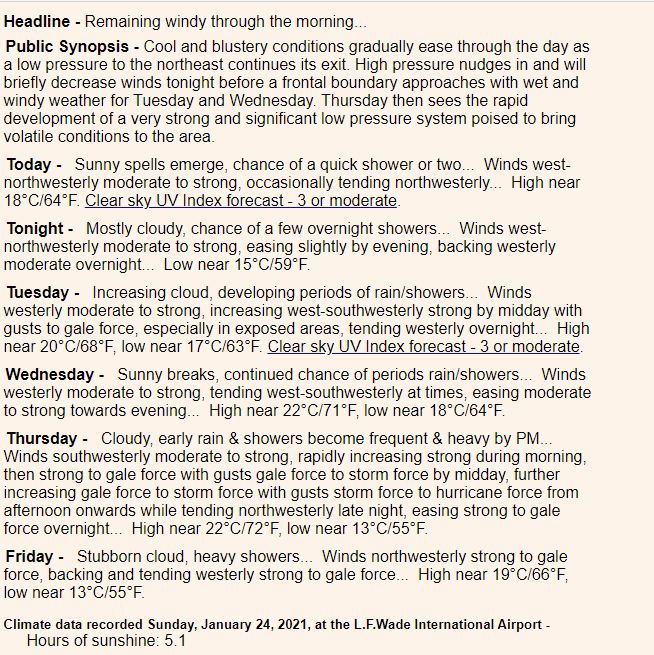
Thursday, February 12th 2026
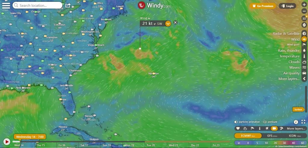
A low pressure system to the north drives a cold front over the Island this morning with periods of rain, gusty showers and a possible rumble of thunder. A wedge of more settled conditions briefly moves in this afternoon, lasting through Friday, then a secondary trough brings cloud and a few stray showers overnight. Weekend high pressure brings welcomed brighter, drier and less windy weather.
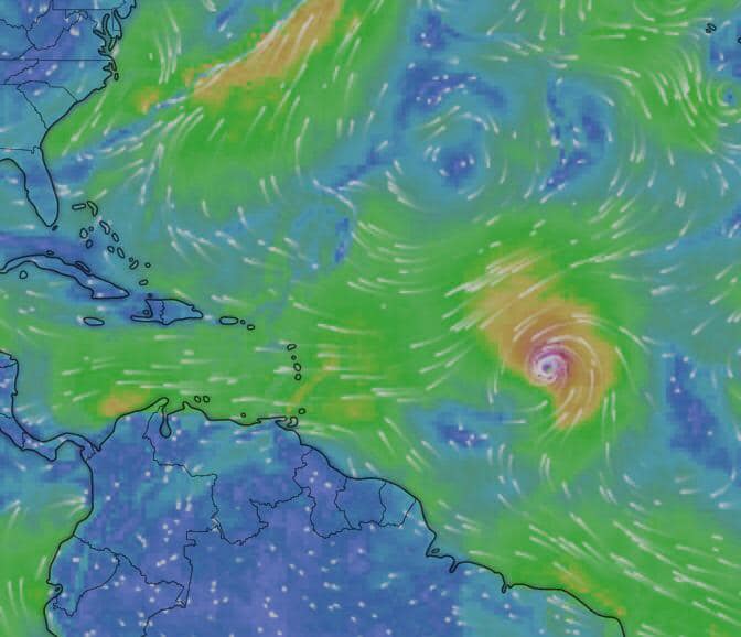
Humberto has gone through some inner-core structural changes.
Earlier aircraft data indicated that the hurricane had a double
eyewall structure, but a 29/0546 UTC AMSR2 microwave pass indicates
that the inner eyewall is starting to get overtaken by the outer
eyewall.  Given the the apparent continued weakening of the inner
eyewall as inferred from GOES-19 imagery since the time of the
microwave pass, Humberto's maximum sustained winds are probably near
the lower end of the recent objective and subjective estimates, so
the initial intensity is nudged downward slightly to 115 kt.
Another Air Force plane will be in Humberto in a few hours to better
assess the intensity.
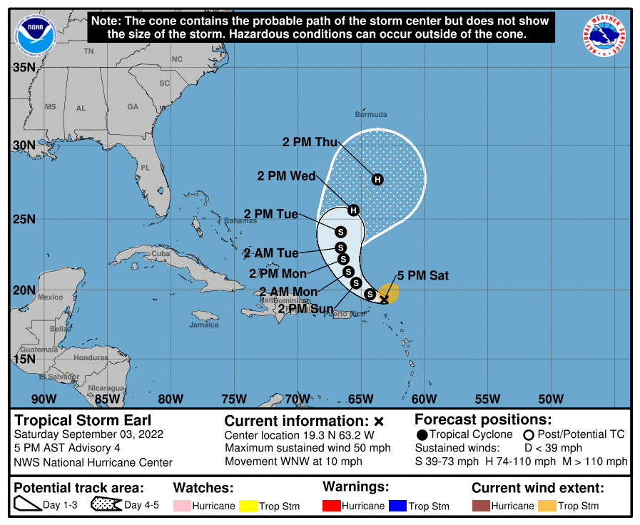
Hurricane Erin was weaker on Sunday but still a Category 3 storm with 125 mph winds, according to the National Hurricane Center.
But Erin is expected to remain a powerful and dangerous storm, and it has already prompted a mandatory evacuation in North Carolina.

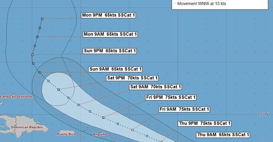
The Ministry of National Security advises that as of 12:00 p.m. today, the Bermuda Weather Service (BWS) has reported that Erin has strengthened into a hurricane.

The system was located 968 nautical miles to Bermuda’s south-southeast, moving west-northwest at 16 knots (18 miles per hour). Erin had maximum sustained winds of 65 knots (75 miles per hour) with gusts to 80 knots (92 miles per hour).

The Bermuda Weather Service has confirmed that Erin is not considered a threat to Bermuda at this time. The Ministry will continue to monitor updates from the BWS as the system progresses.

The Emergency Measures Organisation (EMO), which coordinates Bermuda’s responses to national emergencies and disasters, will meet at 12:00 p.m. on Monday to review the latest developments and to assess Government readiness should any impacts to Bermuda be expected.

Residents are reminded to follow the official forecasts from the Bermuda Weather Service at www.weather.bm and to use this weekend to review their household preparedness plans.

The Government portal provides guidelines on hurricane preparedness, including a list of recommended supplies.

The Ministry will issue further updates following Monday’s EMO meeting.
Wednesday, October 2nd 2024
Upgraded to hurricane status Tuesday night, now Category 3 Kirk is expected to become even stronger in the next few days, the NHC said.

Kirk is currently located 1185 miles east of the Northern Leeward Islands with maximum sustained winds of 120 mph and a minimum central pressure of 955 mb, making the system a major hurricane.

The NHC says Kirk could reach Category 4 status soon as the system moves northwest at 10 mph. On Friday, Kirk is expected to take a further turn north at a faster forward speed.
According to the National Hurricane Center, Tropical Storm Kirk, which formed on Monday morning, will gradually increase in power over the next few days. The NHC predicts Kirk will become a hurricane by Tuesday night or Wednesday morning. The storm will continue to gain momentum after that and become a “very large major hurricane” sometime on Wednesday.

Currently, Tropical Storm Kirk is emitting maximum sustained winds of around 60 miles per hour, which extend outward up to 115 miles. Those speeds will only increase, and Kirk will continue ramping up toward hurricane status.
Friday, August 16th 2024
Hurricane Ernesto
Ernesto has maximum sustained winds of 100 miles per hour, enough to make it a Category 2 hurricane

https://www.wjcl.com/article/hurricane-debby-track-spaghetti-models/61788638

TALLAHASSEE, Fla. − Hurricane Debby, now a tropical storm, roared ashore Monday along the Big Bend coast of Florida, killing at least four people, flooding streets and causing widespread power outages as the storm continued toward Georgia and South Carolina, where it’s expected to bring catastrophic flooding this week.
“Tornadoes, catastrophic flash and urban flooding, coastal flooding, rip currents, strong gusty winds are all expected,” in parts of the Southeast over the next several days, the National Weather Service said.
Hurricane Beryl
Hurricane Beryl made landfall on the Yucatan Peninsula just northeast of Tulum, Mexico, as a strong Category 2 hurricane, according to a special advisory at 6:05 a.m. from the National Hurricane Center.
Hurricane Beryl ripped off roofs in Jamaica, jumbled fishing boats in Barbados and damaged or destroyed 95% of homes on a pair of islands in St. Vincent and the Grenadines before rumbling toward the Cayman Islands and taking aim at Mexico’s Caribbean coast after leaving at least seven dead in its wake.
Hurricane Beryl is closing in on Jamaica, where it will deliver a devastating combination of “life-threatening storm surge” and destructive winds Wednesday. It will then take a swipe at the Cayman Islands Wednesday night into Thursday. The storm could be one of the strongest to impact Jamaica in more than 15 years. Stay updated on its path here.
Hurricane Beryl strengthened to Category 5 status late on Monday after it ripped doors, windows and roofs off homes across the southeastern Caribbean with devastating winds and storm surge fuelled by the Atlantic’s record warmth.

Beryl made landfall on the island of Carriacou in Grenada as the earliest Category 4 storm in the Atlantic, then late in the day the National Hurricane Centre in Miami said its winds had increased to Category 5 strength.
Fluctuations in strength, and later a significant weakening, were forecast as the storm pushes further into the Caribbean in the coming days.
Hurricane Beryl exploded overnight, growing into a Category 5 hurricane with 165-mph winds, according to the 2 a.m. advisory from the National Hurricane Center.

And it’s still intensifying.
When it made landfall at 11 a.m. on Carriacou Island Monday, July 1, it was a Category 4 storm with 150-mph winds.

Hurricane Beryl has rapidly intensified into an extremely dangerous Category 4 hurricane with maximum sustained winds of 130 mph. It’s the earliest Category 4 hurricane on record in the Atlantic Basin. As it approaches the Windward Islands, it brings life-threatening winds and storm surge to the Caribbean.

Sunday, June 30th 2024

High pressure that is gradually retreating east will maintain cloudy skies with the chance of a couple showers. Light to moderate winds increase through today ahead of a few showers that arrive on Saturday. Showers then increase late Saturday night as a cold front approaches from the west and slowly passes on Sunday. Conditions become less humid on Monday.

Monday, April 8, 2024
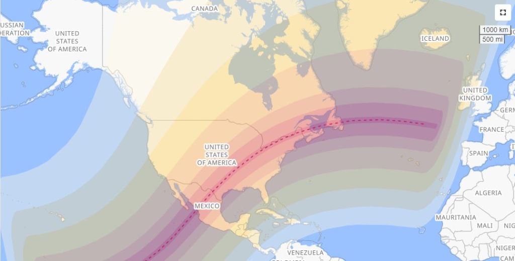
A total solar eclipse is taking place on Monday, April 8, 2024, visible across North America and dubbed the Great North American Eclipse by some media.[1][2][3] A solar eclipse occurs when the Moon passes between Earth and the Sun, thereby obscuring the image of the Sun for a viewer on Earth. A total solar eclipse occurs when the Moon’s apparent diameter is larger than the Sun’s, blocking all direct sunlight, turning day into darkness. Totality occurs only in a narrow path across Earth’s surface, with the partial solar eclipse visible over a surrounding region thousands of kilometers wide.
Occurring only one day after perigee (perigee on Sunday, April 7, 2024), the Moon’s apparent diameter will be 5.5% larger than average. With a magnitude of 1.0566, its longest duration of totality will be of 4 minutes and 28.13 seconds about 4 mi (6 km) north of the Mexican town of Nazas, Durango.
This eclipse will be the first total solar eclipse to be visible in Canada since February 26, 1979,[4][5] the first in Mexico since July 11, 1991,[6] and the first in the United States since August 21, 2017. It will be the only total solar eclipse in the 21st century where totality will be visible in Mexico, the U.S., and Canada.[7] It will also be the last total solar eclipse visible in the contiguous United States until August 23, 2044.
The final solar eclipse of the year will occur six months later, on October 2, 2024.
Distant low pressure to the northeast will lift showery weather out of the area this morning, allowing high pressure to build in from the west. This brings mostly settled weather with an easing breeze through the day. Cooler temperatures hang around for a bit but rebound on Tuesday.
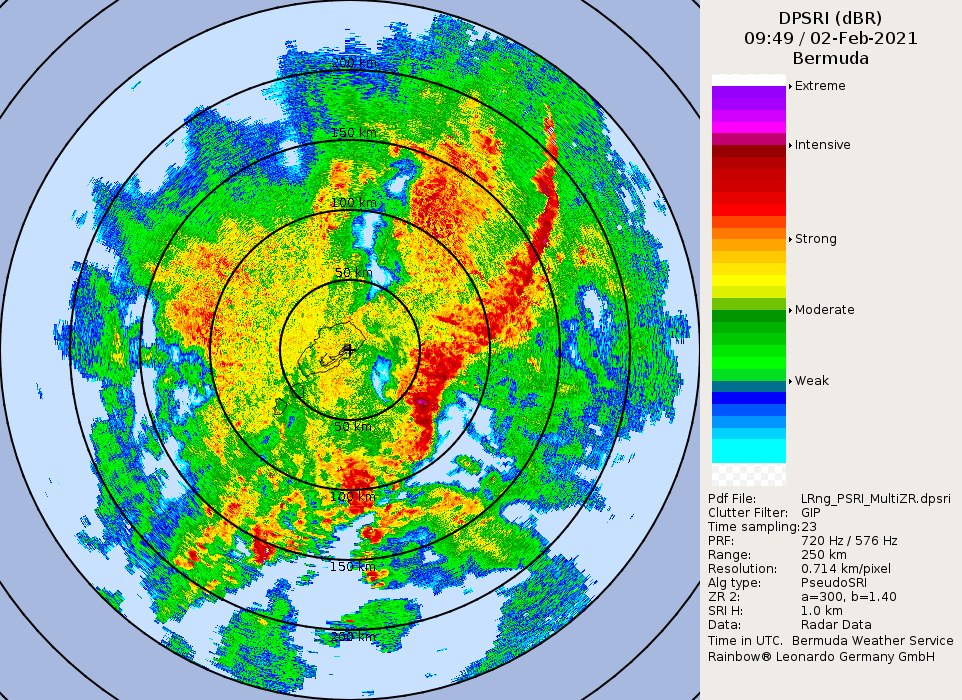
Thursday –
Sunny periods & a few blustery showers, more so in afternoon… Winds northwesterly moderate to strong, decreasing moderate late night… High near 19°C/67°F, low near 16°C/60°F. Clear sky UV Index forecast – 4 or moderate.
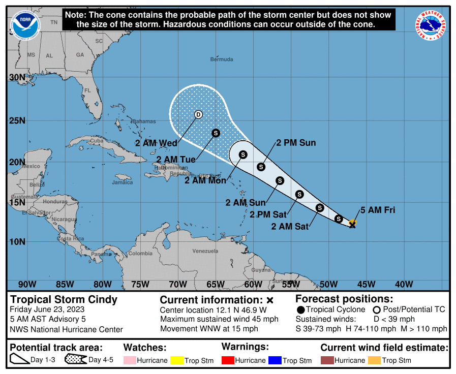
Tropical Storm Tammy set to swipe the Caribbean
Hurricane Tammy made landfall over the island of Barbuda as a Category 1 storm Saturday night, according to the National Hurricane Center.
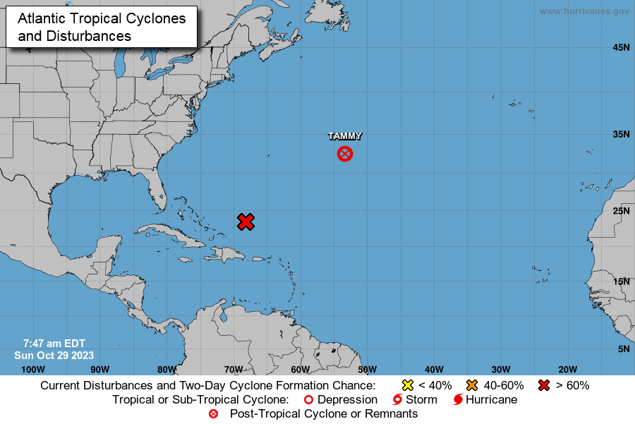
The island did not sustain major infrastructural damages, but did see heavy rainfall and high winds, according to the Associated Press. The storm also knocked down power lines causing an island-wide blackout, the AP reported.
In Guadeloupe, no injures were reported however there was significant damage to buildings and infrastructure, Radio France Internationale reported.
In addition to Hurricane Norma in the east Pacific, Tropical Storm Tammy is swirling in the Atlantic, heading for the Leeward Islands.
The peak of the busy 2023 Atlantic hurricane season may be over, but the tropics are still active.
Tammy strengthened into a hurricane Thursday morning, even after 18 named storms and a January storm that the National Hurricane Center concluded afterward should have been named.
The storm is forecast to move near or over the Leeward Islands east of Puerto Rico on Saturday and Sunday, then turn northeastward into the Atlantic. The center warns the Virgin Islands and Puerto Rico could see up to four inches of rain.
Bermuda to feel Philippe’s wrath before heading for New England this weekend
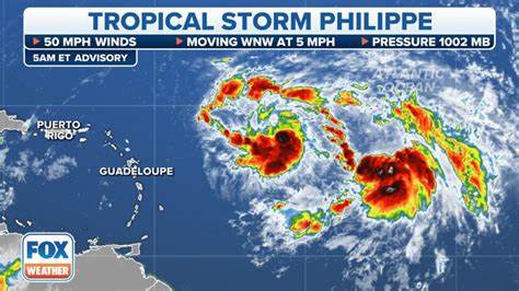
Forecasters are tracking Tropical Storm Philippe in the Atlantic Ocean as it makes its way toward Bermuda and then eventually bring impacts to New England by this weekend.
MIAMI (AP) — Tropical Storm Philippe is threatening to unleash heavy rains and flash flooding in the Leeward Islands on Monday before eventually recurving out into the central Atlantic where it could gain hurricane status around midweek, forecasters say.
The U.S. National Hurricane Center in Miami said at 5 a.m. Monday that Philippe was about 125 miles (200 kilometers) east-southeast of Barbuda. Top sustained winds were at 50 mph (85 kph) with higher gusts and Philippe was moving northwest at a slightly increased 7 mph (11 kph).


A tropical storm watch was in effect for Antigua and Barbuda. The hurricane center said interests in the northern Leeward Islands should monitor the storm’s progress as the center of Philippe was forecast to pass near or just northeast of the northern Leeward Islands on Monday.
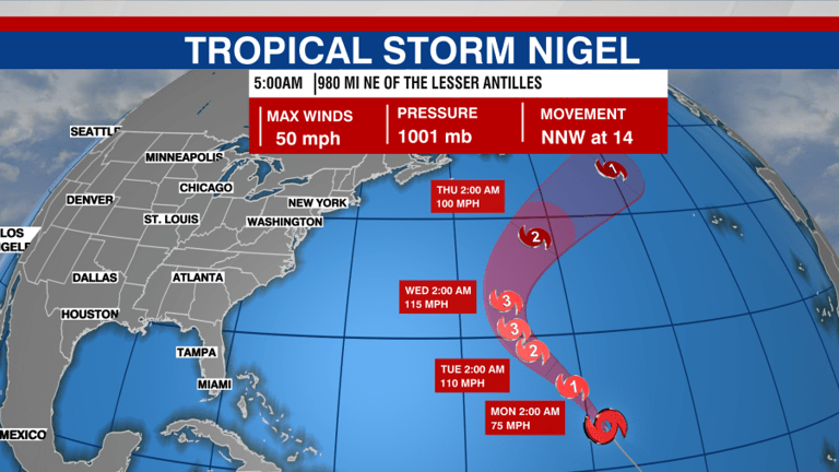
Sept 18 (Reuters) – Storm Nigel has strengthened into a hurricane and could intensify on Tuesday, the U.S. National Hurricane Center, said on Monday.
The hurricane was located about 935 miles (1,510 km) east- southeast of Bermuda, packing maximum sustained winds of 80 mph (130 kph), the NHC said.
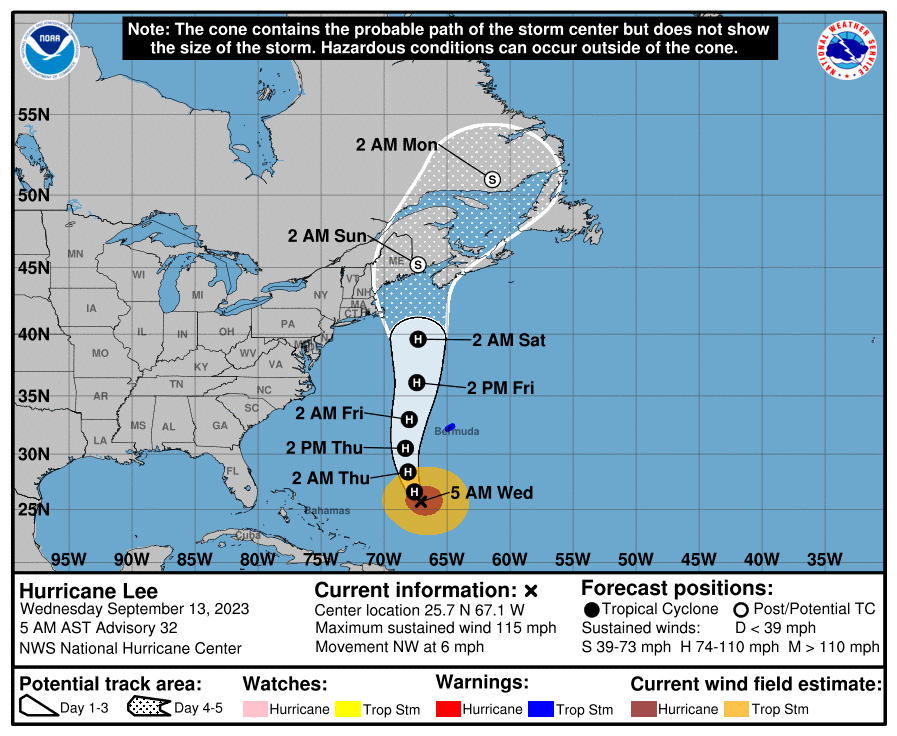
Hurricane Lee is expected to intensify into an “extremely dangerous” category four storm by the weekend, says the US National Hurricane Center (NHC).
According to Click Orlando, as of 11 a.m. EST, Lee is now a Category 2 hurricane with winds of 105 mph, with the latest update predicting it to strengthen into a powerful Category 5 hurricane.
“Lee is expected to continue to rapidly strengthen over the weekend,” they reported. “The official forecast from the National Hurricane Center is a Category 5 hurricane passing northeast of the Caribbean Islands by the start of the weekend.”

As moderate west wind begins to back southwest at times, there is a greater likelihood of increased cloud directly overhead, creating Morgan`s Cloud.

Thursday morning, satellites show two vertical hot towers, which are intense thunderstorms, rotating around the center of circulation, which ClickOrlando states is a “textbook sign that rapid intensification is underway”.

The ridge nudges back in from the northeast on Thursday offering brighter skies and fewer showers around.
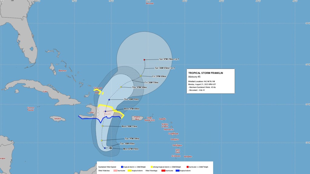
The Tropical Storm Warning in association with Hurricane Franklin ended at 6am this morning.
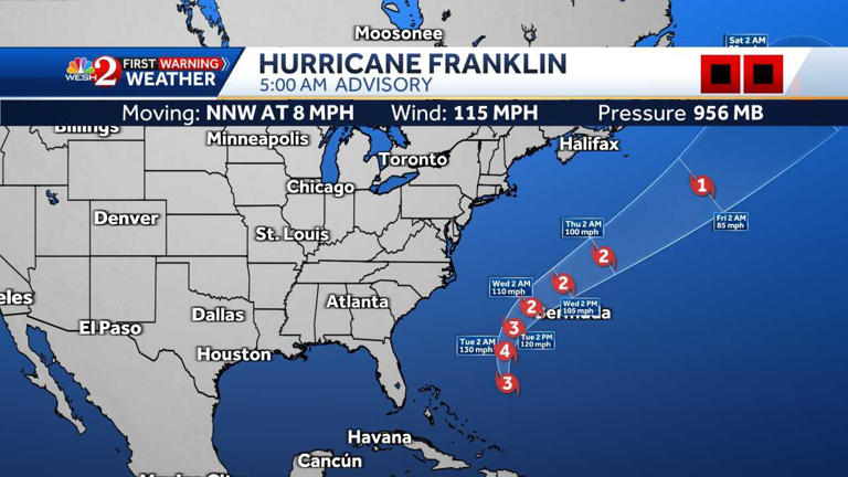
As Franklin clears away northeast, conditions improve with easing winds and mostly fine and dry weather today.
Heading into the weekend Tropical Storm Idalia approaches from the west, bringing the potential for further wet and quite windy weather. Hazardous surf, swells and rip currents gradually diminish today.
Weak areas of convergence will bring one or two showers today. Category 2 Hurricane Franklin is a potential threat to Bermuda and continues to be closely monitored. Franklin is expected to rapidly intensify over the next day or so and then weaken as it passes by to our north on Wednesday. Dangerous swells and rip currents will continue to develop. However, the potential for tropical storm conditions towards midweek is decreasing.
Tropical Storm Franklin is being closely monitored to our distant south and is expected to slowly advance north in the coming days.
A weak frontal boundary lingering across the area is maintaining occasional cloudy periods with a few showers.

Light to moderate north northeasterly winds will soon veer northeasterly while increasing to moderate.
High pressure remains dominant over the area through Sunday night, maintaining sunny and settled conditions. A few troughs from the east bring increased winds and a few showers Sunday morning and again late Monday night into Tuesday.
A series of troughs will continue to bring occasional unsettled weather with gusty winds in association with showers and thunderstorms for the remainder of this week and into the weekend. In between these troughs, winds will vary between south and west, while conditions ease somewhat and skies brighten.
NHC issuing advisories for the Atlantic on TS Bret and TD Four.
An area of unsettled weather is producing clusters of gusty showers and thunderstorms across the area along with patchy rainfall at times. Between these clusters sunny breaks may shine through. Showery weather may persist through the weekend as the region remains rather unstable, although Sunday has the best chance for brighter skies to dominate.
A complex low will move in from the west this evening and strong gusty winds return with bouts of unsettled weather through midweek as a series of troughs move through our area. Cooler temperatures continue over the coming days.
Windy conditions continue today as a low pressure develops to the northwest. Winds strengthen further and a period of gales develops later this afternoon into Wednesday as the low drags a cold front across the area. Wet weather follows into the night, before the front exits and leaves a blustery pattern with showers lasting into Thursday.

ATLC GALE WARNING...
.ATLC WITHIN 31N68W TO 31N81W TO 30N81W TO 28N76W TO 29N70W TO
31N68W SW TO W WINDS 20 TO 30 KT. SEAS 8 FT.
.24 HOUR FORECAST WITHIN 31N47W TO 31N54W TO 29N60W TO 28N55W TO
28N52W TO 31N47W SW TO W WINDS 20 TO 30 KT. SEAS 10 TO 15 FT.
WITHIN 31N56W TO 31N66W TO 30N64W TO 30N58W TO 31N56W W TO NW
WINDS 20 TO 30 KT. SEAS 11 TO 14 FT. ELSEWHERE WITHIN 31N35W TO
31N72W TO 27N68W TO 22N53W TO 22N35W TO 31N35W WINDS 20 KT OR
LESS. SEAS 8 TO 15 FT IN NW SWELL.
.36 HOUR FORECAST WITHIN 31N50W TO 31N52W TO 30.5N51.5W TO
30.5N50.5W TO 30.5N50W TO 31N50W W TO NW WINDS 30 TO 35 KT. SEAS
16 TO 20 FT. ELSEWHERE WITHIN 31N49W TO 31N57W TO 29N56W TO
28N55W TO 31N49W NW WINDS 20 TO 30 KT. SEAS 13 TO 18 FT. WITHIN
31N39W TO 31N49W TO 28N54W TO 26N50W TO 28N44W TO 31N39W SW TO W
WINDS 20 TO 30 KT. SEAS 12 TO 17 FT. REMAINDER AREA WITHIN
31N35W TO 31N69W TO 23N58W TO 20N42W TO 22N35W TO 31N35W WINDS
20 KT OR LESS. SEAS 8 TO 14 FT IN NW SWELL.
.48 HOUR FORECAST WITHIN 31N35W TO 31N40W TO 27N43W TO 26N40W TO
28N35W TO 31N35W SW TO W WINDS 20 TO 30 KT. SEAS 11 TO 15 FT.
WITHIN 31N40W TO 31N49W TO 28N48W TO 27N45W TO 30N41W TO 31N40W
NW WINDS 20 TO 30 KT. SEAS 14 TO 19 FT. ELSEWHERE WITHIN 31N35W
TO 31N66W TO 25N63W TO 18N51W TO 16N35W TO 31N35W WINDS 20 KT OR
LESS. SEAS 8 TO 14 FT IN NW SWELL.


2022
Sub-tropical storm Nicole to the distant southwest will continue to send spells of cloudy and wet weather across the Island, before a cold front sweeps in from the north on Wednesday, introducing drier and brighter conditions. It will turn increasingly windy as the cold front moves across the area.

Strong high pressure to the north and developing low pressure to the distant south will maintain breezy conditions into the start of the new week. The low will send increasingly showery conditions towards the Island tomorrow and into Tuesday.

A weak frontal boundary nears the island from the northwest this afternoon bringing cloudier skies, breezy to windy conditions and a few showers. The front will clear the area by this evening, though windy conditions remain in its wake persisting into the weekend. Brighter skies are poised to return from tomorrow with seasonal temperatures.
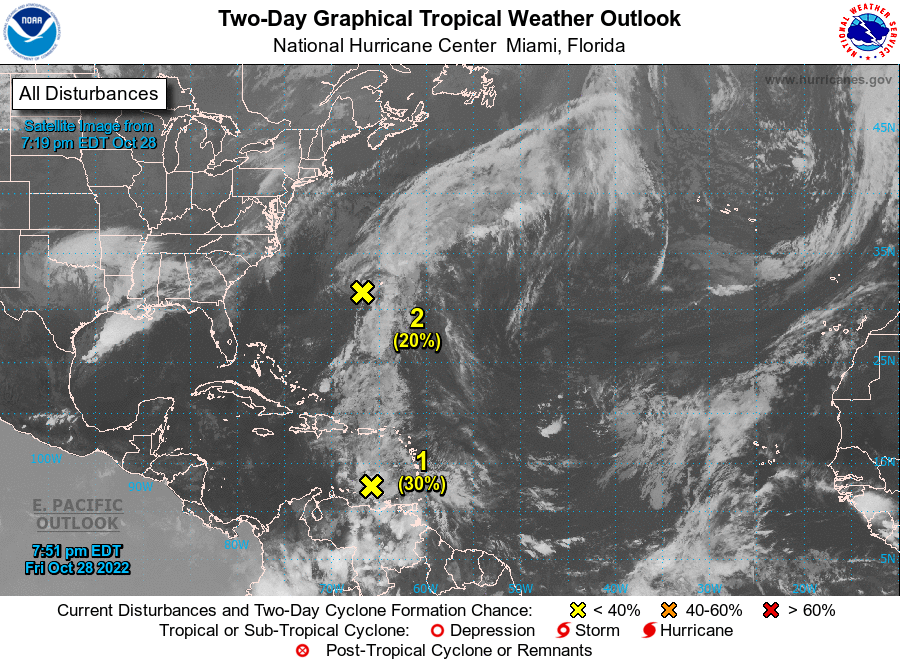
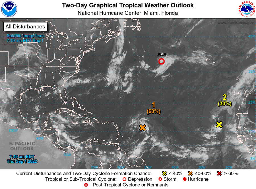
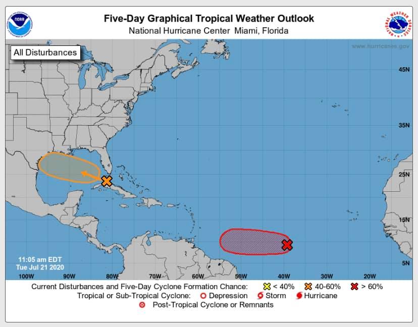
1. Southwestern Atlantic:
A trough of low pressure over the southwestern Atlantic Ocean
continues to produce a broad area of disorganized showers and
thunderstorms. A surface low pressure system is forecast to emerge
along the northern portion of the trough axis tonight or Friday,
and some subsequent development could occur through Saturday. By
late Saturday, upper-level winds are forecast to become less
conducive for development, and the low is expected to begin
interacting with an approaching frontal system.
* Formation chance through 48 hours...low...30 percent.
* Formation chance through 5 days...low...30 percent.

Conditions will gradually deteriorate as an area of low pressure approaches from the south-southwest. Expect cloudy periods and an increasing likelihood of rain or showers, as well as occasionally breezy weather for a few days.
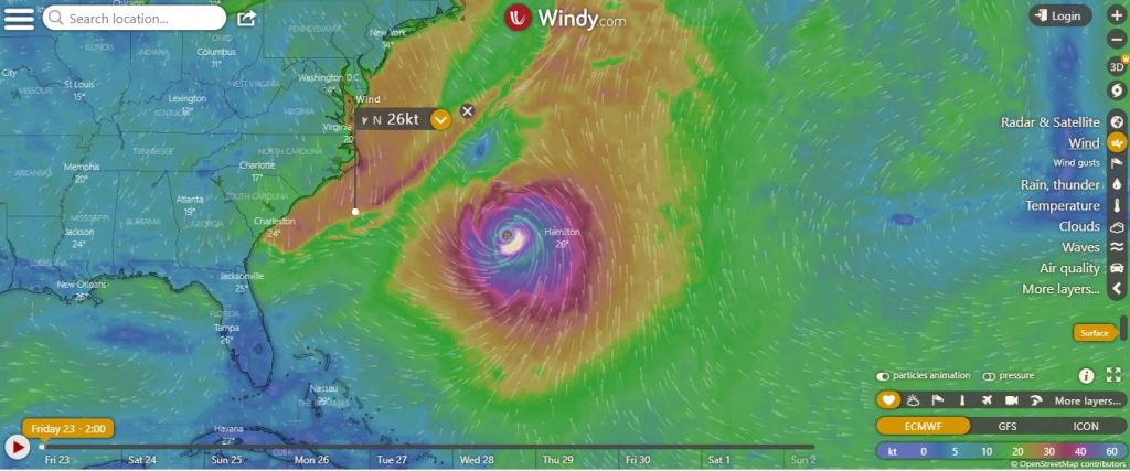


Hurricane Fiona is a “potential threat to Bermuda”, the Bermuda Weather Service said, with its closest point of approach to Bermuda within 72 hours forecast to be 377 nm to the SW at 6am on Thursday [Sept 22] with the BWS noting “this system may move closer to Bermuda after this time period depending upon its track.”
The BWS discussion noted that the models suggest that Fiona could bring “storm force winds and hurricane force gusts during the late night on Thursday into early Friday morning” and said that a “hurricane watch may be issued from as early as Tuesday.”


Hurricane Earl continues to approach from the south and is expected to show signs of tracking farther to the northeast this afternoon as it intensifies. Local conditions will rapidly deteriorate. Tropical storm winds are expected late this afternoon into early Friday with gusts near hurricane force at times within heavy showers and widespread rain as rain bands spread across the region. Dangerous seas with rip currents and hazardous surf will continue along coastal areas.


September 2022
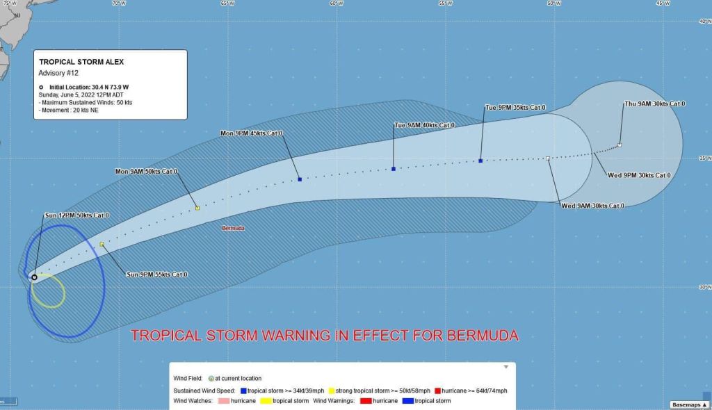
The Minister of National Security, Michael Weeks convened an Emergency Measures Organisation (EMO) to get the latest update on Tropical Storm Alex.
A Tropical Storm Warning remains in effect. The latest forecast at 6.00pm, shows Alex’s closest point of approach to be some 67 nm to the NNW of Bermuda at 10.00 am Monday. According to the BWS, the island can expect to experience the onset of unsettled weather conditions from late tonight into Monday.
Out of an abundance of caution and in the interest of public safety, Government services will commence at 1.00p.m. tomorrow, following the passage of the storm.
All public schools will be closed tomorrow. Public transportation – buses and ferries – will be suspended tomorrow morning.
Also due to the approaching storm, the Ministry of Transport advised of the following flight cancellations for tomorrow:
AA2830 (MIA)
AA825 (PHL)
AA2044 (CLT)
Travellers are encouraged to contact their respective airlines for more information.
There will also be hazardous surf and rough seas tomorrow associated with TS Alex. Therefore, public beaches will be closed to swimming due to dangerous rip currents. As a public safety measure, the Department of Parks have put up dangerous surf signs along the public beaches.
The Causeway remains open and will continue to be monitored.
Full Statement: https://bit.ly/3MlcBsI
📫Please forward this message to those who may need this information.
🇧🇲 Received this message from a friend? Click on the link (wa.me/14415046045)to start a chat, text the word “Hi” and follow the instructions to receive the Government of Bermuda’s information, news, and updates.


Strong southerly winds will strengthen further as a robust low pressure system moves in from the west. Occasional gale force wind may gust near storm force, especially at elevated or exposed locations or within periods of showers that may be heavy at times as well as any thunderstorms that might form. The front clears to the east tonight and for the rest of the week much colder temperatures and blustery showers are expected.

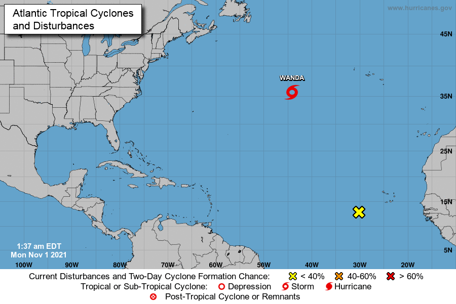
WANDA HOLDING STEADY IN STRENGTH AS IT MOVES ERRATICALLY OVER THE CENTRAL ATLANTIC.
Low pressure to the south merges with a cold front approaching from the west thus igniting rainy and thundery periods, while southerly wind increases through much of today. Aside from isolated showers, the island improves on Sunday into early Monday as high pressure passes to our north.


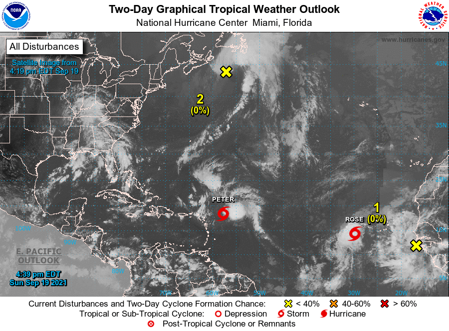
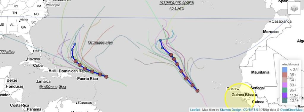

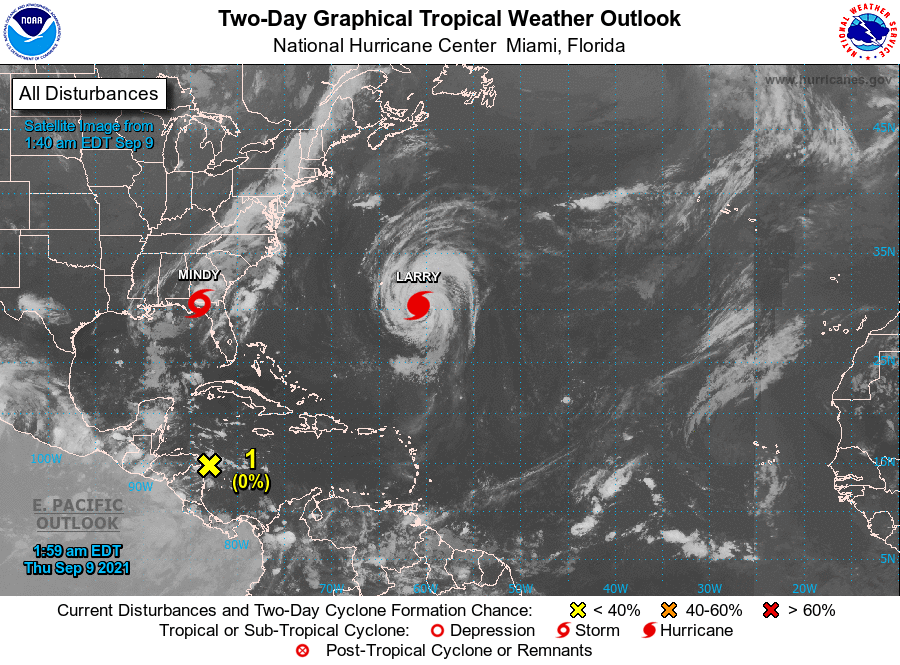
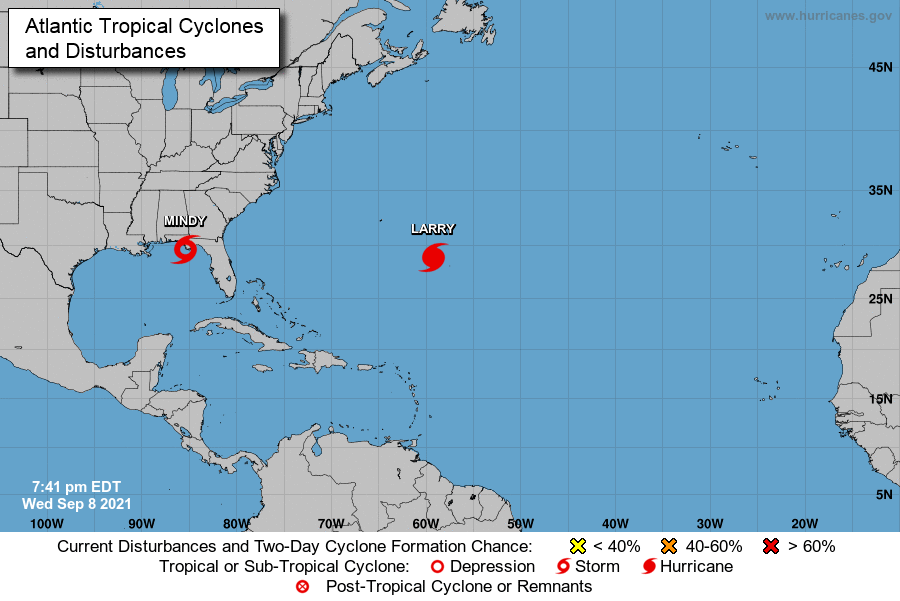
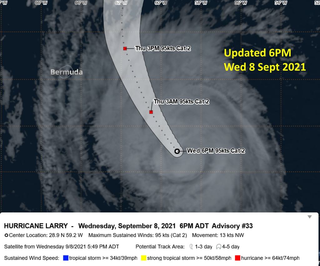
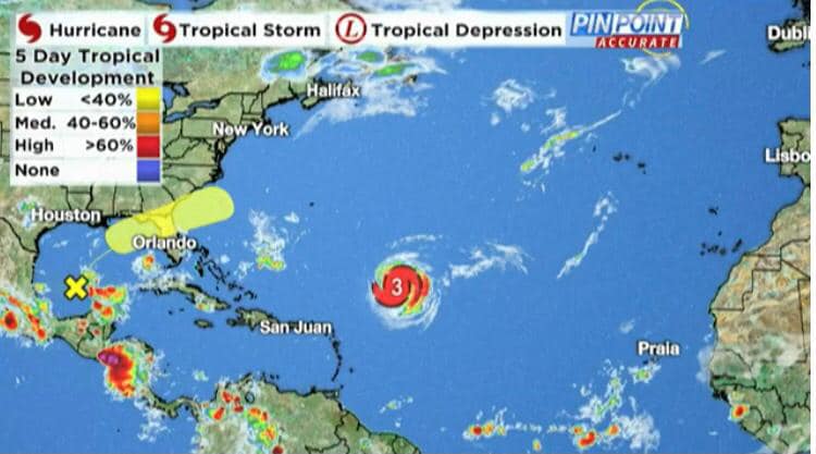
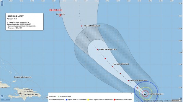


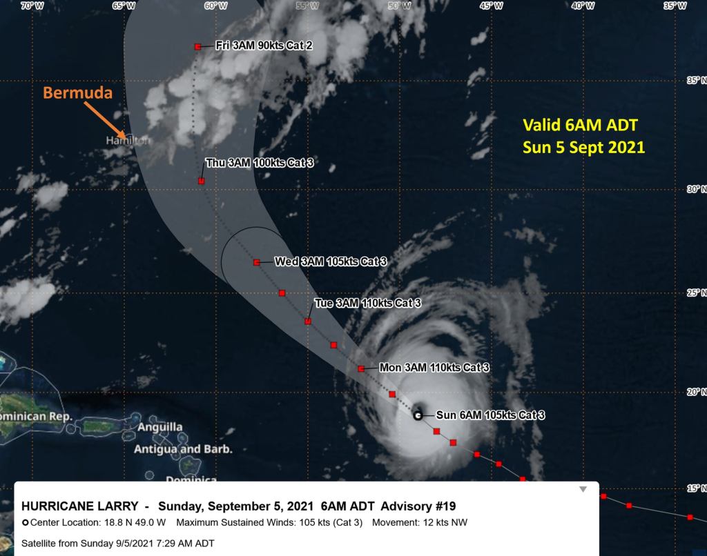
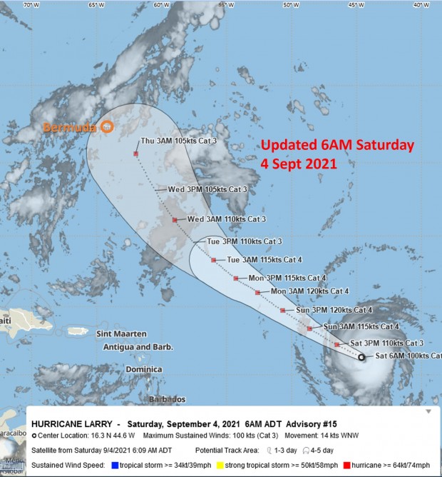
As of 8am this morning [Sept 5] the BWS also stated, “Category 3 Hurricane Larry continues to churn away in the central North Atlantic, currently located about 1,350 miles southeast of Bermuda.
“Forecast tracks are more confidently for a passage east of Bermuda, but dangerous seas offshore and hazardous surf are likely to still affect the Marine Area & south shore beaches for much of this week. Strong gusty winds may also affect us mid-week. Keep up to date at http://www.weather.bm.”
Both the BWS and Minister of National Security have urged the public to be prepared, noting that this is a very active hurricane season.

September 4, 2021 | 0 Comments
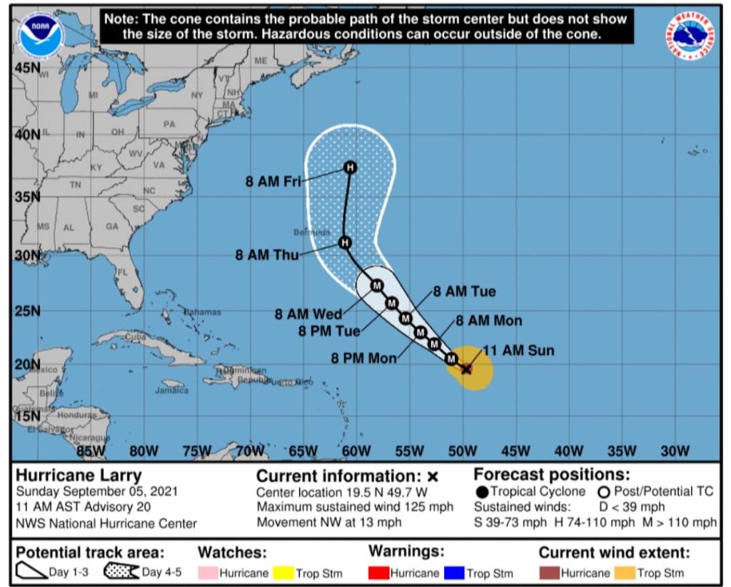
Noting that there is “still a lot of uncertainty,” the Bermuda Weather Service [BWS] said that Hurricane Larry is “forecast to make a close approach to Bermuda on Wednesday night and Thursday of next week” and “ it would be prudent to review your hurricane plans, and make any early preparations.”
The BWS posted the image below and said, “Larry is now a Category 3 hurricane, with maximum sustained winds of 115 mph. Larry is still in the distance, at about 1675 miles from Bermuda to the southeast. Larry is expected to stay a major hurricane over the next few days, and is forecast to make a close approach to Bermuda on Wednesday night and Thursday of next week.
“Although there is still a lot of uncertainty, it would be prudent to review your hurricane plans, and make any early preparations. Regardless of Larry’s exact track, it is certain that large swells will be building, with hazardous seas developing offshore by the end of the holiday weekend and into next week. South shore beaches are also likely to be affected by potentially dangerous surf. Keep abreast of the real-time and forecast conditions at http://www.weather.bm.”Minister of National Security Renee Ming has urged the public to remain vigilant as the 2021 hurricane season continues, with Minister Ming noting that this “holiday weekend is a good opportunity for the public to review their hurricane plans.”
She said, “As a timely reminder, we are sharing a few helpful tips so that the public can ensure they are properly prepared in the event of a serious storm.”
“Make any repairs around your home.
“Trim your trees or any overhanging branches back.
“Carefully review your family plans and update them with any changes to phone numbers and other important information.
“Take stock of all medical prescriptions that your family and/or pets require and ensure you have at least two weeks supply on hand.
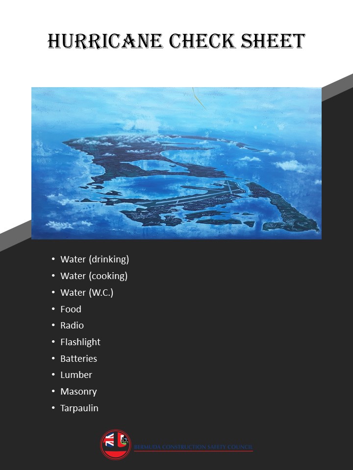
“Check your hurricane kit to make sure you have working flashlights, a portable radio with spare batteries and a stock of non-perishable food to last your family for seven days.
“Make sure you have disposable utensils.
“Stock up on baby & children’s items [food and liquid formula, diapers, wipes]
“Ensure you have cooking and heating equipment & fuel.
“A portable cooler or ice chest is useful to have.
“Make sure you charge all your cell phones, tablets and laptops. Also have wireless chargers on hand.
“Please check with your vulnerable neighbours and ask them if they need any help with their preparations.”
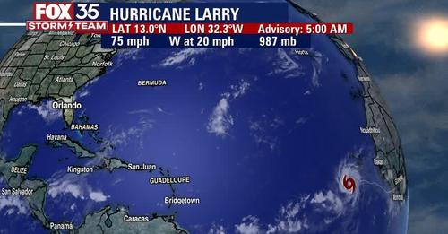


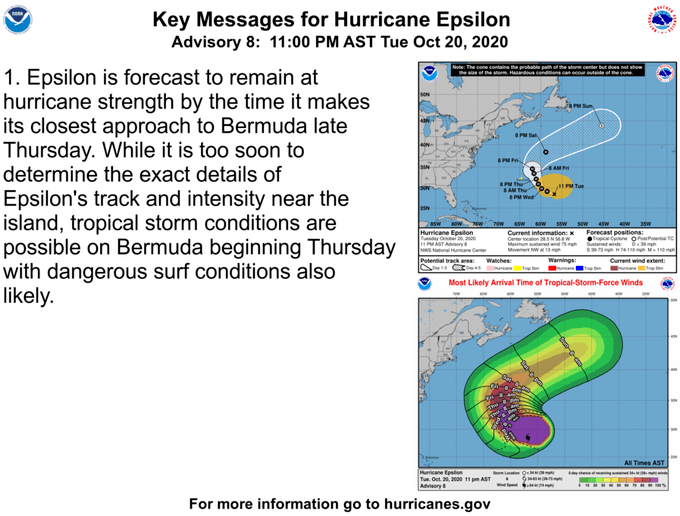
Hurricane Epsilon intensified to a “major” Category 3 storm on Wednesday, picking up 50 mph in wind speed in 24 hours, according to the National Hurricane Center.

The 10th hurricane of an extremely active Atlantic season, Epsilon has prompted a tropical storm warning for Bermuda, though the storm is forecast to miss the tiny island nation.

Even if the center of the hurricane does not hit Bermuda, its outer winds are expected to affect the island, as tropical-storm-force winds extend as many as 345 miles out from the center of the hurricane. Epsilon should make its closest approach to Bermuda on Thursday evening.


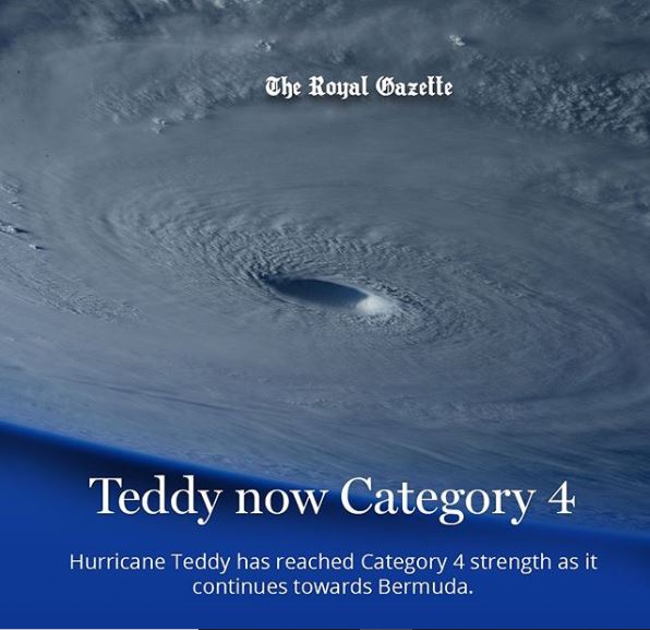
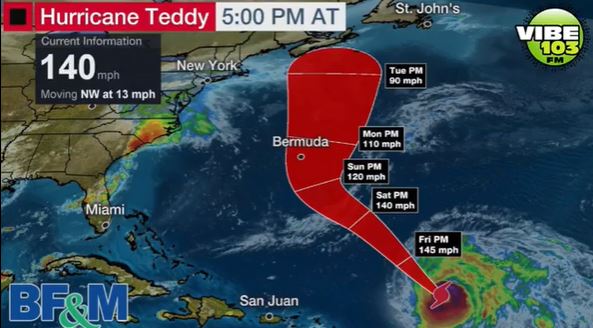
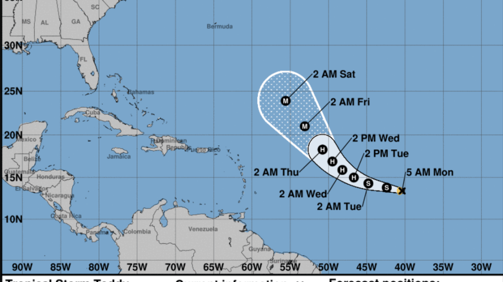
Hurricane Teddy having reached Category 4 strength begins its approach to Bermuda causing increased wave activity seen from the South Shore and is expected to cross the island as a Category 2 hurricane 100 miles from land on Monday, September 21st 2020.
Hurricane Teddy is a threat to Bermuda

A tropical storm warning is in effect for Bermuda
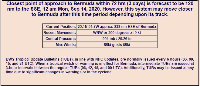
Closest point of approach to Bermuda within 72 hours is forecast to be 104 nm to the ESE, 12pm, Monday, September 21st 2020. However the system may move closer to Bermuda after this time period depending on its track.

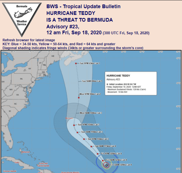
We continue to monitor Hurricane Teddy as it intensifies to our distant southeast, and is now considered a potential threat to Bermuda.
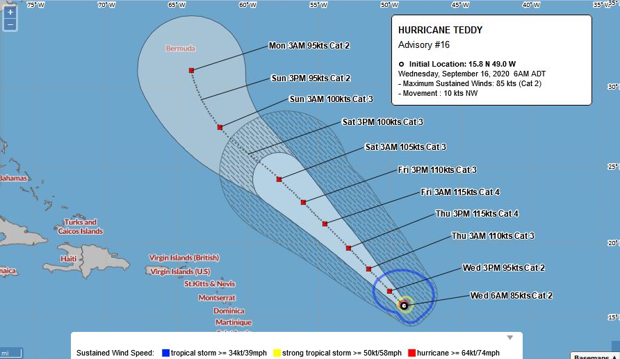
| Sep 16 | 09:00 GMT | 15.8 | -49 | 100 mph | 976 mb | Hurricane | 2 |
| Sep 16 | 15:00 GMT | 16.5 | -49.7 | 100 mph | 973 mb | Hurricane | 2 |
| Sep 16 | 21:00 GMT | 17.5 | -50.8 | 100 mph | 973 mb | Hurricane | 2 |
| Sep 17 | 03:00 GMT | 17.8 | -51.5 | 90 mph | 976 mb | Hurricane | 1 |
| Sep 17 | 09:00 GMT | 18.3 | -52.3 | 105 mph | 970 mb | Hurricane | 2 |
| Sep 17 | 15:00 GMT | 19.3 | -53 | 120 mph | 957 mb | Hurricane | 3 |
Expect a return of hazardous swells and very unsettled conditions late this weekend into early next week as it merges with an approaching front moving in from the northwest.
As of the 11 p.m. update, Tropical Storm Teddy was on track to strengthen into a powerful Category 3 hurricane, and its track led in the direction of Bermuda.
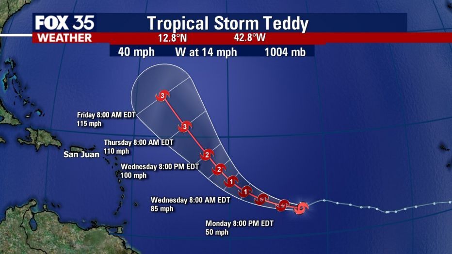
Teddy, which formed Monday morning, was about 1,100 miles east of the Lesser Antilles Monday evening. It was moving west near 13 mph with maximum sustained winds near 50 mph with higher gusts.
Forecasters said Teddy could strengthen into a hurricane as soon as Tuesday as the storm heads northwest toward Bermuda. The warm water, which is a few degrees hotter than average this year, is expected to help Teddy hit major hurricane-level strength by Thursday.

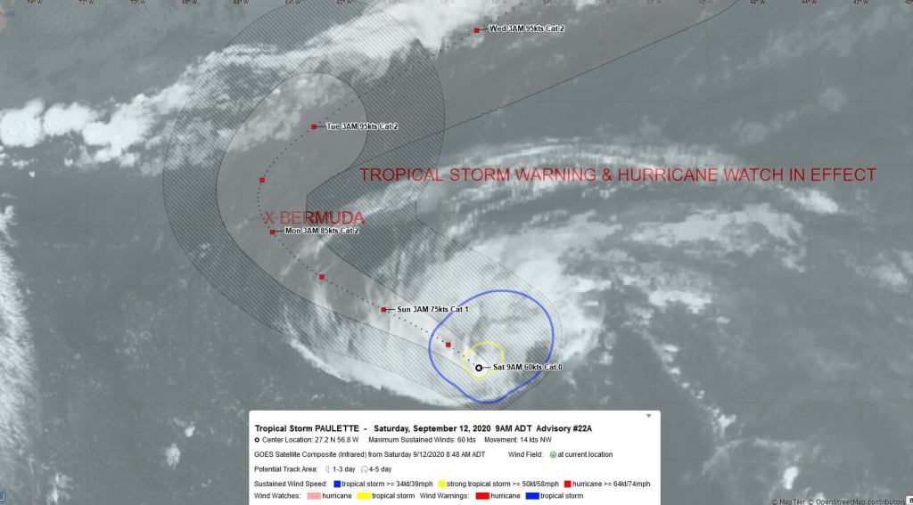
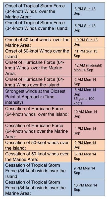
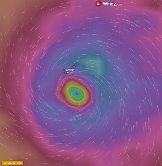
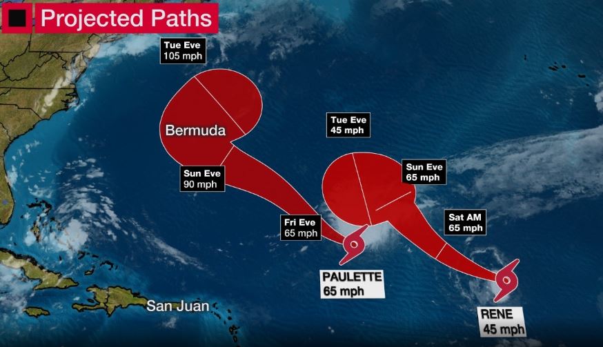
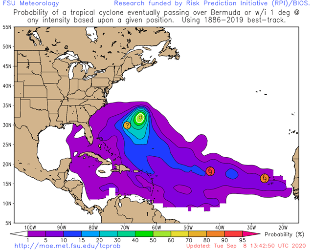
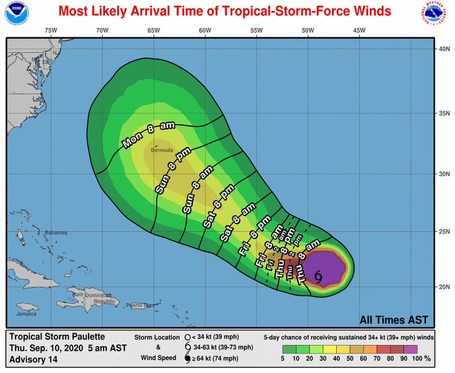
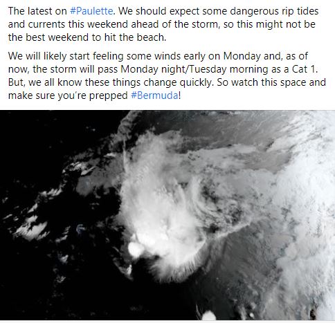
Hurricane Paulette: Monday, September 14th 2020.
By Leigh Morgan

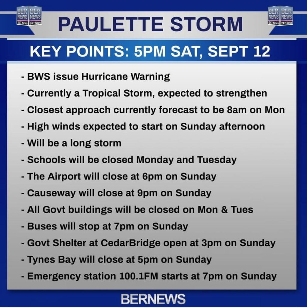
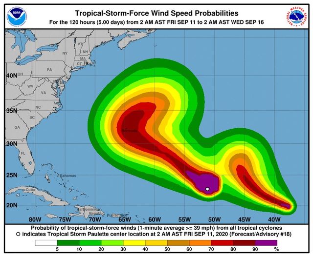
Tropical Storm Paulette remained near hurricane strength on Saturday while tracking steadily closer to Bermuda, where a hurricane warning has been issued.

The National Hurricane Center said Paulette could become a hurricane tonight, and it could pass near or over Bermuda on Monday morning.
Forecasters were also tracking Tropical Storm Sally, which appeared headed for the northern Gulf Coast as a hurricane next week, Tropical Depression Rene, which is no threat to land, Tropical Depression 20, which is also no immediate threat to land, and two other tropical waves as of Saturday.


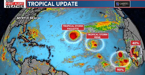
The westernmost system, Paulette, is expected to remain at tropical storm strength for the next few days. It is being hindered right now by unfavorable upper-level winds and dry air. However, its wind shear is expected to diminish by this weekend, which is expected to allow it to strengthen to a hurricane.


Furthermore, Paulette is expected to curl north early next week, then northeast over the Atlantic Ocean after that. How sharp that northward curl is and the timing of that turn is important, as it could bring the center of Paulette near Bermuda early next week, likely at hurricane strength.
Those in Bermuda should monitor the forecast closely.
Swells generated by Paulette will spread from the Lesser Antilles, Puerto Rico and Hispaniola to the Bahamas and the southeast U.S. coast this weekend. Dangerous rip currents and breaking waves can be expected at the beaches.

OMAR: became the record-earliest 15th storm of any Atlantic hurricane season.


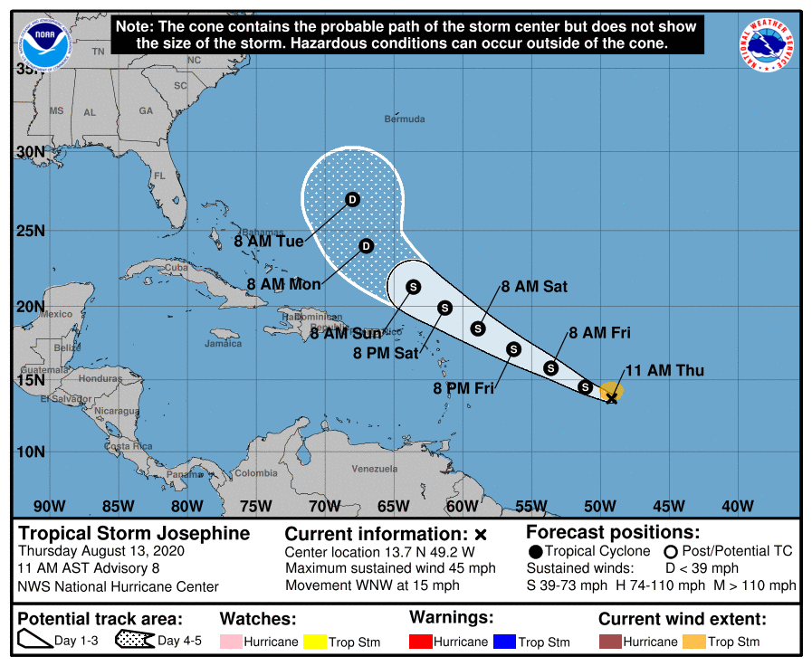
Josephine


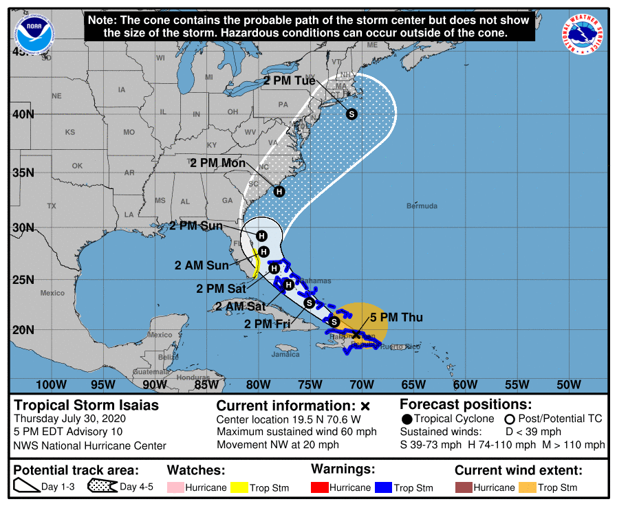
ISAIA

ISAIAS REGAINS HURRICANE STRENGTH AND IS EXPECTED TO MAKE LANDFALL TONIGHT WITH DANGEROUS WINDS AND STORM SURGE… …STRONG WINDS AND HEAVY RAINFALL LIKELY FROM THE EASTERN CAROLINAS TO THE MID-ATLANTIC COAST TONIGHT AND TUESDAY…


Gonzalo

https://www.gov.bm/coronavirus


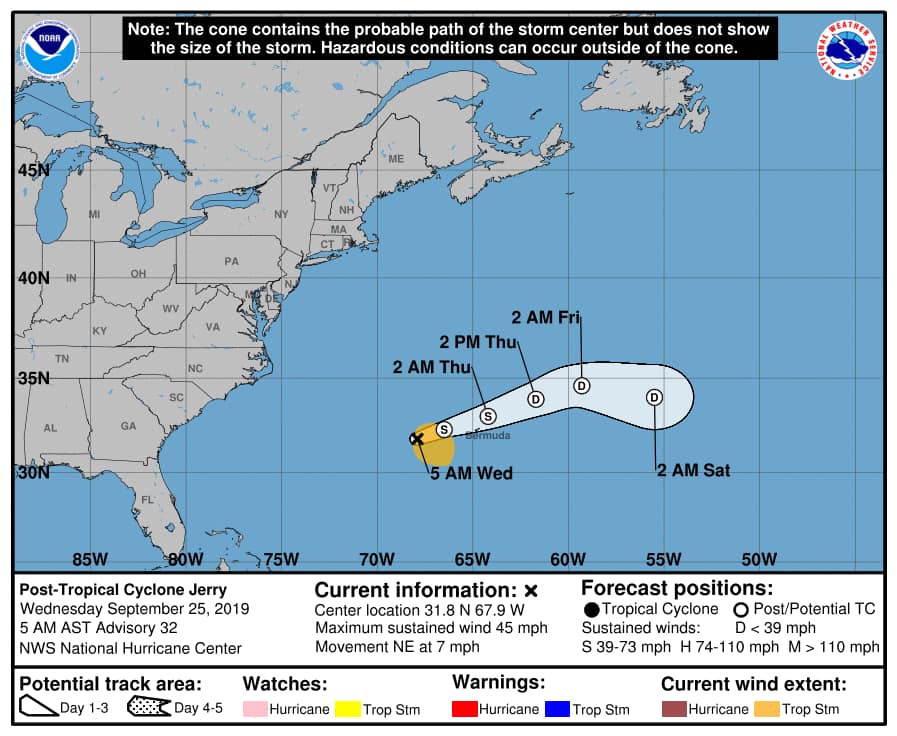
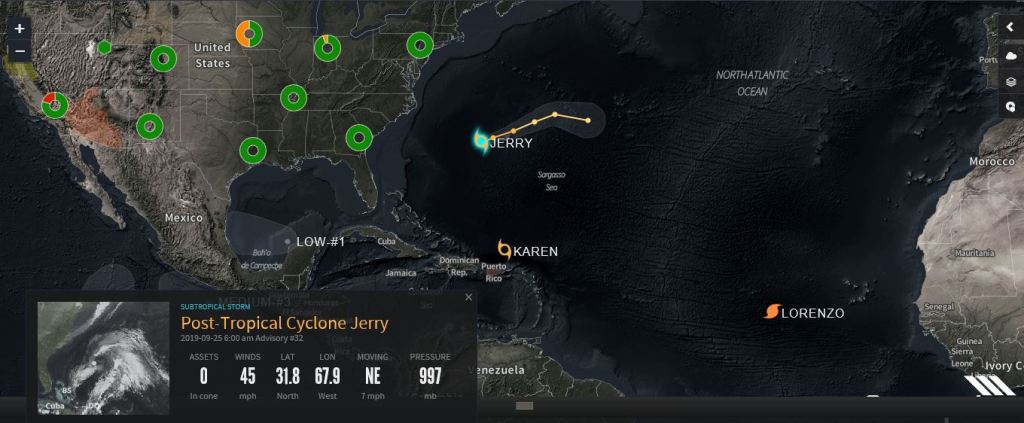
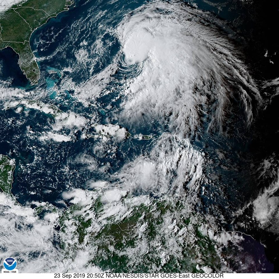
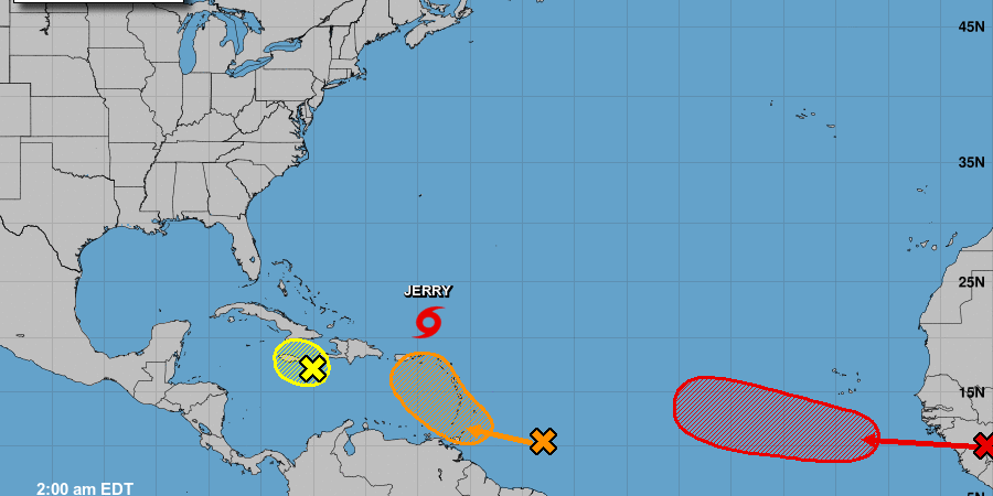
Jerry, Karen & Lorenzo 9/23/2019


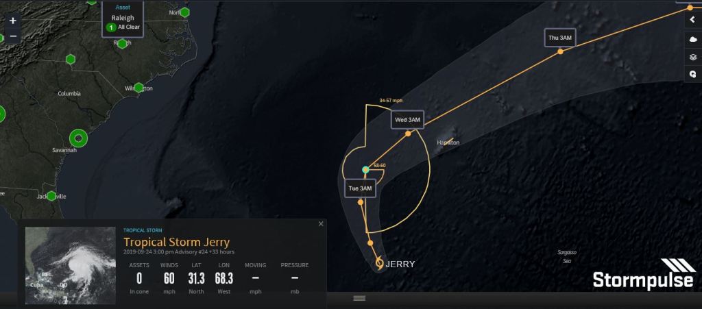
Jerry 9/22/2019

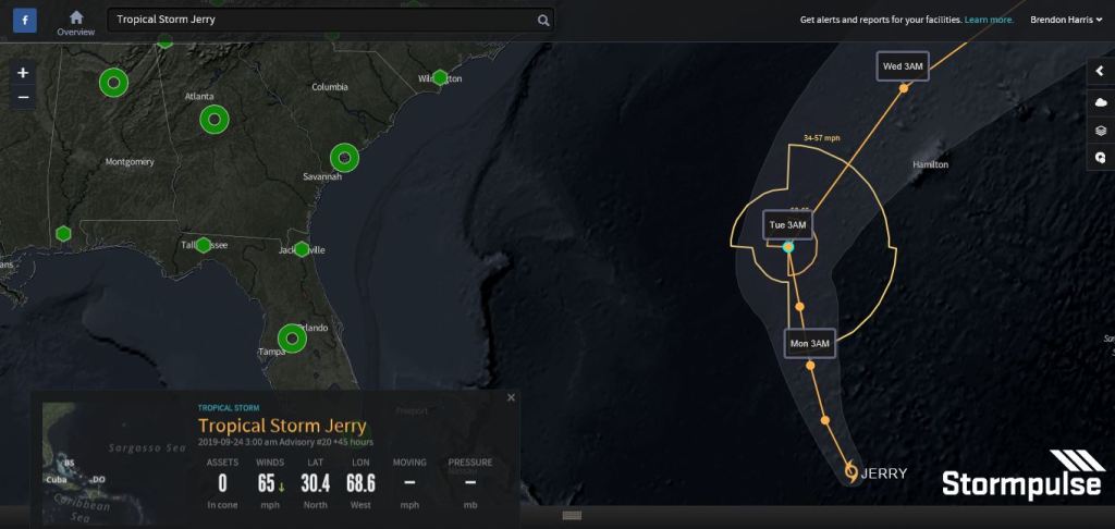
Jerry 9/21/2019
BWS – Bermuda Weather Service9 hrs
Jerry is currently a Tropical Storm, but NHC forecast intensifies it to a Hurricane as it passes Bermuda within 100nm in 72hrs (making it a THREAT). As we have witnessed recently, forecast intensity can change dramatically in the days leading up to the passage of a tropical system. Please keep updated with the latest BWS information. Tropical Update Bulletins are released 12am/pm & 6am/pm local time. Under watch or warning there is an intermediate advisory which gives an update to the current position and intensity, but not the forecast track- that is found only in the full advisories.
12 noon Sat 21 Sept: JERRY NOW A THREAT
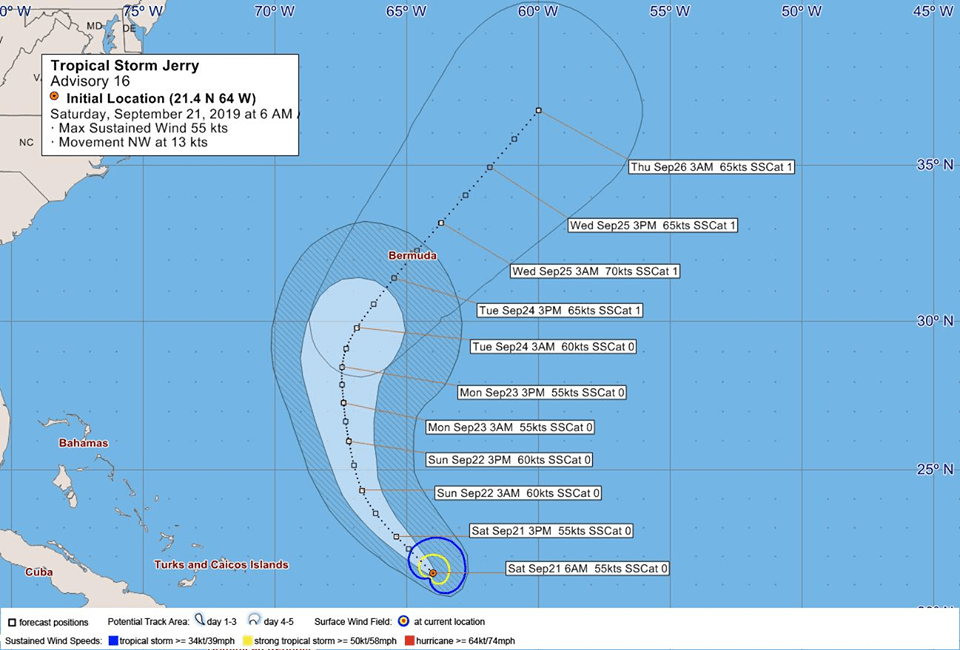


Saturday Morning Update on Jerry:
– It is currently a Tropical Storm
– BWS; Remains a ‘potential threat to Bermuda’
– NHC: Fluctuations in strength likely during next days
– More info: http://bernews.com/Jerry19
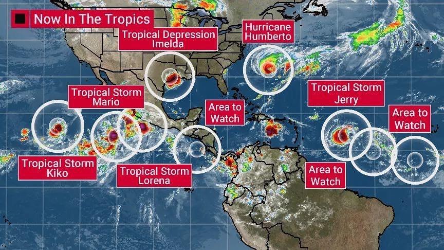
Jerry Upgraded to Category 1 Hurricane With 11 Storm Systems Brewing in the Atlantic & Pacific
Hurricane Jerry 9/20/2019
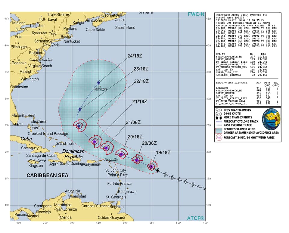
As of 5:00 a.m. AST (09:00 UTC) September 20, Hurricane Jerry is located within 20 nautical miles of 18.4°N 58.7°W, about 290 mi (465 km) east of the northern Leeward Islands. Maximum sustained winds are 90 kn (105 mph; 165 km/h), with gusts to 110 kn (125 mph; 205 km/h)). The minimum barometric pressure is 981 mbar (28.97 inHg), and the system is moving west-northwest at 14 kn (16 mph; 26 km/h). Hurricane-force winds extend up to 25 miles (35 km) from the center of Jerry, and tropical storm-force winds up to 80 miles (130 km) from the center.
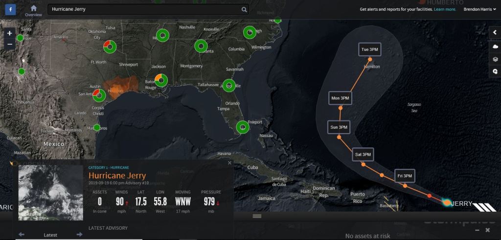
Hurricane Jerry remained a Category 2 storm Friday morning but is expected to weaken throughout the weekend, according the National Hurricane Center’s 5 a.m. update.
Jerry is moving west-northwest at 16 mph with maximum sustained winds of 105 mph. It is about 290 miles east of the Northern Leeward Islands and is expected to dump heavy rains over the islands as it passes them to the north later today.
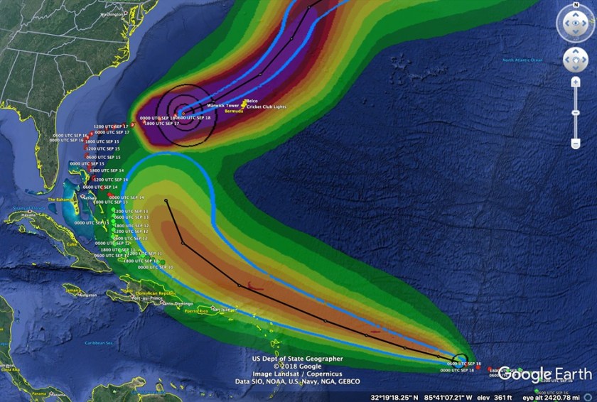
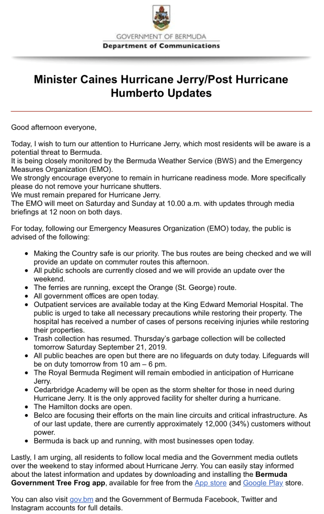
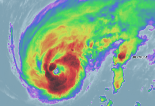
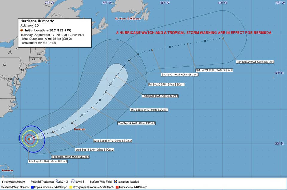
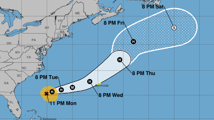
Hurricane Humberto 9/19/2019.
Humberto started producing hurricane-force winds on Bermuda at around 8 p.m. ADT on Wednesday, September 18. By early Thursday morning, Humberto left more than 80% of the island, over 27,900 customers, without power, plunging the island into a blackout.[12] The Bermuda Fire and Rescue Service reported seventeen minor incidents of gas leaks, nine medical incidents, and three structural fires that were caused by Humberto.[13]
Governor of Bermuda, John Rankin, called up to 120 members of the Royal Bermuda Regiment to prepare for recovery efforts. The Minister of National Security in Bermuda, Wayne Caines, stated that schools, government offices, and ferries on Bermuda closed at noon and bus services stopped at 4 p.m.[11]
Hurricane Humberto 9/18/2019.
Closest point of approach to Bermuda within 72 hrs (3 days) is forecast to be 78 nm to the NW, 8 pm Wed, Sep 18, 2019. However, this system may move closer to Bermuda after this time period depending upon its track.
Current Position: 32.2N 68.1W approx. 168 nm W of Bermuda
Recent Movement: ENE or 65 degrees at 14 kt
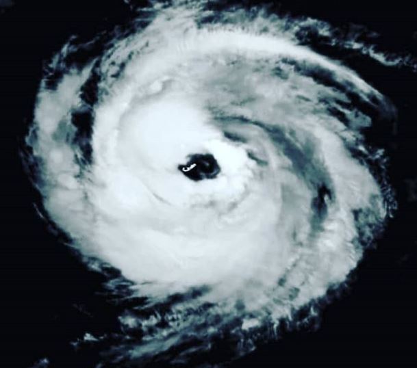
Hurricane Humberto has been upgraded to a CAT 3.
Hurricane Humberto is the eighth named storm, third hurricane, and second major hurricane in the 2019 Atlantic hurricane season. Humberto is currently active and is expected to produce hurricane-force winds in Bermuda.
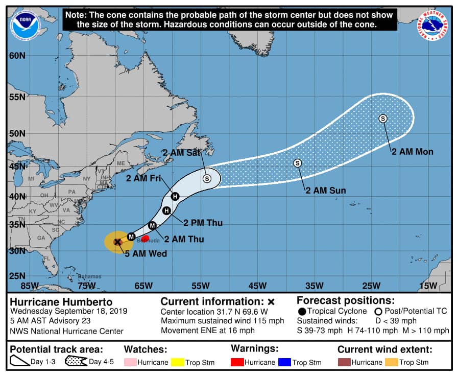
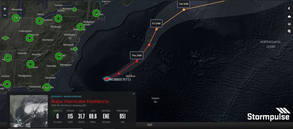
5:00 AM AST Wed Sep 18
Location: 31.7°N 69.6°W
Moving: ENE at 16 mph
Min pressure: 951 mb
Max sustained: 115 mph
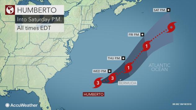
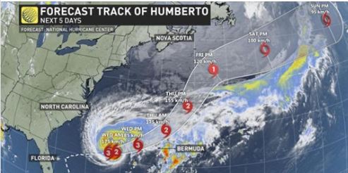
Humberto reached Category 3 major hurricane strength on Tuesday night as it tracked closer to Bermuda. The powerful hurricane is expected to skirt just north of the islands with rain, wind and pounding seas.
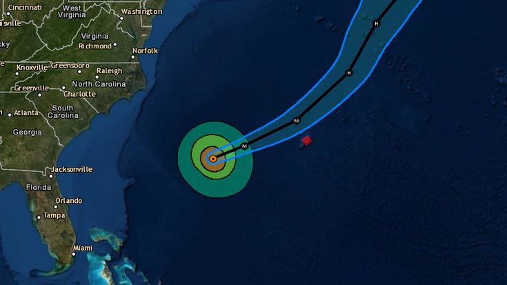
As of 5 a.m. EDT Wednesday, Humberto was located about 285 miles west of Bermuda and moving east-northeast at 16 mph with maximum sustained winds of 115 mph with higher gusts. A hurricane warning is in effect for Bermuda.
Hurricane Humberto was upgraded to a major Category 3 hurricane overnight as Bermuda wakes up this morning under a hurricane warning for the local area.
As of 10pm Tuesday night, the storm was located some 405 miles WSW of the island, moving and picking up speed, packing winds up to 115 mph.
Forecasters also say the pressure has dropped to 951mb, with little change in the forecast track.
Satellite images show that Humberto will likely maintain Cat 3 strength as it passes through the local area Wednesday night, with hurricane force winds extending more than 60 miles out from its centre.
As the storm continues to strengthen on its current trek toward Bermuda, maximum sustained winds have picked up to 185 km/h.
The National Hurricane Center (NHC) said the forecast track has drifted north, which has lowered the risk of a landfall on Bermuda, but the island remains in harm’s way as the storm approaches.
The NHC expects the storm to remain a powerful hurricane through Thursday.
“Though the centre of the storm is expected to pass just north of Bermuda, Humberto is a large hurricane with an expansive wind field, and that means Bermuda will likely see near-hurricane-force conditions sometime late on Wednesday, even with a near miss.
“Tropical storm winds are expected to impact Bermuda by Wednesday afternoon and linger through Thursday morning and heavy rainfall — as much as 150 mm for some — is expected as the storm passes.
“Humberto will also drive dangerously large ocean swells and breaking waves for Bermuda as well as the southeast coast of the United States for the next few days. Storm surge and large waves are expected to cause flooding in Bermuda, particularly along the southern coast on Wednesday night and Thursday,” the NHC said.

The hurricane is expected to turn fully to the northeast into Thursday.
The storm continues to strengthen on its current trek toward Bermuda, maximum sustained winds have picked up to 185 km/h. The National Hurricane Center (NHC) said the forecast track has drifted north, which has lowered the risk of a landfall on Bermuda, but the island remains in harm’s way as the storm approaches.The NHC expects the storm to remain a powerful hurricane through Thursday…Be SAFE – Bermuda #BermudaReal

HURRICANE HUMBERTO E.M.O. UPDATE ADVISORY:
This Just In:
Everybody should be off the roads by 7pm Wednesday evening.
All public schools will close at 12pm
The last ferry will leave Hamilton at 12pm
All buses will be off the roads at 5pm with the last bus leaving at 4pm
All government offices will close at 12noon and reopen as per
normal on Thursday.
Wednesday’s trash collection will take place on Wednesday
morning. All trash should be on the curb side by 7am. No trash
will be collected after noon or on Thursday.
Access to the causeway will be restricted to emergency vehicles only as of 7pm Wednesday.
The public are strongly advised not to use the
Causeway after this time.
The Bermuda regiment will be embodied.
King Edward will initiate their Hospital Incident Command
tomorrow evening with increased staffing levels.
Ambulances will be strategically assigned around the island.
Belco will have members of staff also position in east, west and central parishes.
Cedarbridge Academy will be open as the storm shelter for those who need from 5pm
The emergency broadcast channel will be live as of 7pm and will provide updates throughout the night.
The public are strongly advised to avoid the roads until given the all clear by the EMO.
No Lifeguards as of 2pm Wednesday and the beaches will close at 6pm.
There will be no outpatient clinics tomorrow.
The next emo meeting will be tomorrow at 10am.
User comments posted on this website are the sole views and opinions of the comment writer and are not a representation of TNN or its staff.
TNN accepts no liability and will not be held accountable for the comments made by users.
TNN reserves the right to remove, edit or censor any comments.
Hurricane Humberto 9/17/2019.

Hurricane Humberto continues to gain power as it heads west into the northern Atlantic where it is expected to become a major storm, the National Hurricane Center said in its 5 a.m. update.
The Cat. 1 Hurricane has maximum sustained winds of 90 mph with higher gusts and is moving at about 8 mph.
“This general motion with a gradual increase in forward speed is expected through early Thursday,” the NHC said. “On the forecast track, the center of Humberto is expected to approach Bermuda Wednesday night.”
Some strengthening is forecast within the next 36 hours where meteorologists expect Humberto to become a major hurricane by Tuesday or Wednesday.
While Humberto is moving away from the United States, the storm’s “life-threatening” swells will still impact the southeastern coast of the country from Central Florida to North Carolina as well as the northeastern Bahamas, the NHC said.
There are two tropical waves in the nearby area meteorologists are keeping their eyes on: the first is in the Gulf of Mexico and has a low chance of development, the second is located in the central tropical Atlantic and has an 90 percent chance of developing into a tropical depression over the next five days.
Hurricane Humberto 9/16/2019

Tropical Storm Humberto 9/15/2019.
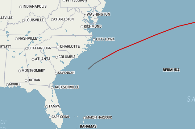
On September 12, at 21:00 UTC, the NHC initiated advisories on Potential Tropical Cyclone Nine.[102] 24 hours later it developed into a tropical depression.[103] On the same day, the depression strengthened into Tropical Storm Humberto.[104]
Current storm information[edit]
As of 5:00 a.m. EDT (09:00 UTC) September 15, Tropical Storm Humberto is located within 30 nautical miles of 28.3°N 77.7°W, about 135 mi (220 km) north-northwest of Great Abaco Island and about 175 mi (285 km) east of Cape Canaveral, Florida. Maximum sustained winds are 50 kn (60 mph; 95 km/h), with gusts to 60 kn (70 mph; 110 km/h). The minimum barometric pressure is 1000 mbar (29.53 inHg), and the system is moving north-northwest at 6 kn (7 mph; 11 km/h). Tropical storm-force winds extend outward up to 160 miles (260 km) from the center of Humberto.
For latest official information, see:
- The NHC’s latest public advisory on Tropical Storm Humberto
- The NHC’s latest forecast advisory on Tropical Storm Humberto
- The NHC’s latest forecast discussion on Tropical Storm Humberto


